TRANSDAT
27.35TRANSDAT: Convert spatial data between different coordinate reference systems
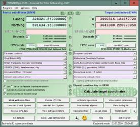
Convert spatial data between different coordinate reference systemsTRANSDAT is a handy application that lets you convert spatial data between different coordinate reference systems. It’s capable of performing coordinate transformations at amazing quality and performance with geodetic reference system change or without it.
It includes a large variety of methods for world-wide coordinates transformations and it even allows you to create a custom measurements set using coordinate definitions with Molodenski or Helmert parameters.
The application enables keyboard input for coordinates and can handle coordinate files in Text, dBase, ArcShape and ArcGenerate formats. TRANSDAT keeps all actions in a log file, has an auto-install Network feature (automatically installs clients on networks), supports batch processing and can be used as DLL in other applications.
Through the programmable GPS UI you can read coordinates from a low cost GPS antenna into a laptop.
Download Details
-
License:
Demo
-
Platform:
Windows
- Publisher:
-
File size:
5.40 Mb
-
Updated:
Jun 25, 2024
-
User Rating:
5.0 / 5 (4 votes)
-
Editors' Review:
Not yet reviewed
-
Downloads:
1,694